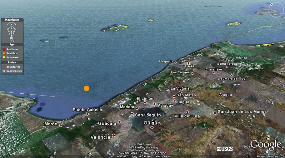
More videos On Saturday, the 12th of September at 20:06 GMT (15:36 local time) happened a strong earthquake opposite to the Port coasts Hair, to 100 km from the city of Caracas, in Venezuela. The seismological services have registered it with magnitudes of: 6.4 USGS (USA) Brings 6.2 FUNVISIS (Venezuela) Brings They can continue the replies on the page of the USGS (or by means of his file of Google Earth), or in Google Earthquake. Regrettably the page of the FUNVISIS does not work for the time being, but for declarations of the sismólogos it is known that several replies have already happened. Meanwhile I leave them with this apprehension of screen of Google Earth of the epicenter (orange point): The USGS explains the causes of the movement:
The earthquake happened to little depth like result of a side fallamiento [or of course]. The tectonics of this area is characterized by the movement to the east of the badge of the Caribbean Sea in contact with the South American badge, at a 20 mm / year approximate speed. It is so there exist important systems of flaws in the region, which accommodate the efforts produced in the crust by the contact of 2 badges. By the place of the today event it is assumed that there might have happened in the flaws San Sebastian or The Prop, which they cover of west to this one close to the epicenter, although a major analysis is necessary. The region that surrounds the event with September 12 is known for being sísmicamente active, having happened strong earthquakes in the past. Some examples are the magnitude earthquake 6.5 in July, 1967 that caused 240 deaths, and the magnitude earthquake 5.4 in May, 1989 that left without hearth more than 2000 persons in the Tucacas region.
Next we have the map of intensities provoked by the earthquake (scale of Mercalli) in the different localities. We can observe that the seismic intensity would have reached up to VI grades Mercalli in the localities nearest to the epicenter. The size of the circles indicates the number of reports in every locality. The earthquake has coincided also with a temporary fortress that had happening in Venezuela, with rains and hurricane-force winds, the situation being more difficult. The Avant-garde brings:
Fourteen persons turned out to be light wounds for the earthquake of 6,2 grades of magnitude that shook today Caracas and the regions of the north center of Venezuela, reported the Venezuelan Minister of Internal Affairs, Tarek Aissami. The holder of Interior and Justice indicated that the affected persons, between them a child and a young woman who suffered wounds in the legs, were attended in hospitable centers and his state does not cover gravity. It pointed out also that seven housings and two hotel complexes of the area incurred losses. The minister confirmed that mortal victims have not been brought and added that the caused ones are evaluated in all the regions affected by the quake. The Aissami indicated that in Caracas the teams of emergency work to withdraw fallen trees and other debris immediately after the strong rains and hurricane-force winds that registered in the capital shortly before feeling the earthquake.
More videos On Tuesday, the 29th of September at 17:48 GMT (06:48 local time) happened a strong earthquake to 200 km to the south-west of the islands Samoa and American Samoa. The seismological services have registered it with magnitudes of: 8.0 USGS (USA) Brings 8.1 EMSC (Europe) Brings They can continue the replies on the page of the USGS (or by means of his file of Google Earth), on the page of the EMSC, or in Google Earthquake. The following apprehension of screen of Google Earth shows a slightly common replies distribution towards the west of the epicenter (major yellow point), one week after the principal earthquake: The USGS tries to explain the cause of the movement (square brackets and linkage added by me):
The earthquake took place close to the north limit of a segment [a pit, similar in that north - North-East of the limit is opposite to the coasts of the Pacific Ocean] of approximately 3000 km long and orientation between the Badges of the Pacific Ocean and of Australia. (...) According to the information about the location and the mechanism of available flaw at present it is possible to infer that the earthquake of September 29 has happened for the rupture of a normal flaw in or close to the bulkiness that suffers the Badge of the Pacific Ocean before getting in subduction in the pit [under the Badge of Australia]. Considering it in his set, the limit of the Badges of the Pacific Ocean and of Australia is one of the regions of major seismic activity in the world.
The tsunami generated from this earthquake has been a devastator in Samoa, American Samoa and Tonga, reaching heights of up to 6 meters, as they can see in the following map (created by the GDACS, also in version.pdf): In a previous entry I have told that the tsunamis are a series of waves (not only one) that is generated when an earthquake fulfills some conditions:
Epicenter in the sea: This earthquake happened in the sea, to 200 km to the south-west of Samoa.
Vertical movement of the ocean floor (fallamiento normal or inverse): This earthquake happened for a normal fallamiento, which is slightly common in the area (it will be necessary to wait for a study detailed to speak about this point with more clarity).
Magnitude bigger than 6.5: This earthquake had a magnitude of 8.0.
Minor 60 km depth: This earthquake had a 18 km depth.
Como pueden ver, se cumplieron todas las condiciones. Cabe mencionar que se han dado casos en los que, a pesar que se cumplen las condiciones, no se genera un tsunami. Pero para quienes se encuentran en el área afectada por el sismo, si éste ha sido bastante fuerte y se encuentran cerca de la costa, la recomendación es evacuar a zonas altas inmediatamente, y no esperar una alerta oficial. The video and the map that they observe are a simulation of the wave of tsunami (created by the NCTR), with the target to estimate the time of arrival and the height of the waves on the coasts of the Pacific Ocean. Because the wave can travel at big speeds in the ocean (800 km/h in average), alerts were expressed for more remote areas, like New Zealand, Hawaii and Japan, but they were cancelled some hours later, because the waves came with minimal heights, of only some centimeters. Reuters brings:
The official number of dead persons in Samoa was 146, but officials added that probably it would increase given the wide number of missing persons. Nearly 20 peoples were destroyed in Samoa and tens were devastated in the near American Samoa. "We have seen vans taking the dead persons (...) back the city", said the tourist neozelandés Fotu Becerra. "It impressed us when we saw the first one, but after three hours it seemed normal to us", he added. On the south coast of the principal island of samoana, Upolu, who suffered the impact of the tsunamis, almost all the palm trees had been started like sticks by the force of the ocean. A layer of mud and sand was covering many ruined buildings, while boats and motorcars were hanging by the trees and survivors were poking between the debris.
Probably at this point, many of you are already informed on the special edition that the popular magazine Science has dedicated the Ardipithecus ramidus,a possible forefather of ours. I emphasize possibly because in the means a series of errors has spread with regard to this hominino, like which he is the "lost link" or the most ancient "forefather of the man". First of all, it is necessary to emphasize that this is not a recent discovery. The first fossil Ardipithecus ramidus remains were found in 1992-1993 and they received his scientific name in 1994. With the time there have been discovered new fossils of the same species, all in the region known as Depression of Afar, in Eastern Africa. On the other hand, I Burned it is the name that has happened to the most finished fossil of the opposing ones, which corresponds to a female. Looking for reliable information I came across with a very good article of the blog The PaleoFreak who answers to all the doubts that can arise about the recent news of Ardi. I quote three of the most beetling:
Is it I burned the most ancient forefather of the man? No. The expression "more ancient forefather of the man", so handled, does not mean anything, has no sense. Although the Ardipithecus was really ours forefather there had always to be an even more ancient forefather, and even more ancient other, etc., up to coming to the origin of the life. Is it at least the fossil of the most ancient hominid? Neither. I burned he lived 4,4 million years ago, but there is big quantity of fossils of much more ancient hominids. For example, the Orrorin has between 6.1 and 5,8 million years. The Sahelanthropus is dated in 7 million years. Also simians are hominids under the current classification like the Sivapithecus, of hace between 8.5 and 12,5 million years. Then Did not I Burn it is not the most ancient of anything? Does not it have any record outstanding? Yes. I burned it is the most ancient fossil skeleton that is known for the time being of a hominino. The homininos (clado Hominina) are a group that includes the human beings and several nearby extinct species, but neither not to the chimpanzees nor to other simians. The homininos are biped, except the most primitive, which theoretically might be quasi-bipeds or even quadruped. The most ancient homininos that I Burned are not represented by remains so finished that there could be called "skeletons". That's why Ardi is compared by Lucy, the classic skeleton of Australopithecus afarensis of 3,2 million years ago.
Author: pnjunction2007. Source: Flickr. The pyrite (FeS2, or ferrous sulfide) is one of the most common iron ores. Since the iron is an essential component of the earth's crust, we can find pyrite in any part of the world. It exists also in a big variety of forms, between which they emphasize for his beauty the buckets (like that of the photo) and the pentadodecaedros (polyhedrons of 12 pentagonal faces), more acquaintances like "piritoedros". Although they it do not believe this mineral it does not have any value any more than esthetic; it is so in the antiquity it has brought uncertainties to many keen explorers and incautious miners who were thinking about having gained the lottery finding gold, hence the " name "from the idiots". In spite of this, the pyrite keeps on being very popular between the collectors of minerals, who tend to look for the most perfect or stranger forms. Now then, there exist varieties of pyrite that can contain gold in very small quantities (auriferous pyrite), by what in mining they are used like indicators for the golden exploration. Nevertheless, for the mining industry the pyrite commonly is more a problem than a benefit; and the fact is that by his value lack this mineral is rejected, going to stop to re-wash (batteries of mining garbage), where it oxidizes and lately it generates the unwanted acidic, extremely harmful drainage for the environment. Happily nowadays methods exist to prepare and also to mitigate this damage. In spite of everything, the pyrite will never stop attracting the curiosity of insiders and outsiders. If they want to enjoy more images of this popular mineral, I recommend to them to visit the galleries of Flickr or of Wikimedia Commons. This entry has been updated and published in parallel in the portal e-ciencia.com More news on minerals in Mineralogy. Blogalaxia Tags:mineral pyrite fotos+de+pirita marcasita piritoedro oro+de+los+tontos --Thanks for reading the MiGeo feed: http://www.migeo.pe/ Torrent Til Death S04E21 The Wedding free
On Friday, the 13th of November 03:05 GMT (12:05 local time) happened to a strong earthquake on the coasts of the region of Tarapacá, to 95 km to the north of the city of Iquique, in Chile. The seismological services have registered it with magnitudes of: 6.5 USGS (USA) Brings 6.4 SSN (Chile) Brings 6.3 IGP (Peru) Brings Until now replies have not registered, as it can be appreciated on the page of the USGS (or by means of his file of Google Earth), on the page of the SSN, or in Google Earthquake. Next we can see the map of intensities of the USGS: According to the reports that have entered (the circle size indicates the number of reports for locality), it is observed that the seismic intensity would have reached up to V grades Mercalli in the localities nearest to the epicenter (which coincides with the information of the ONEMI). Also it is observed that the earthquake has been felt in some cities of the south of Peru. If they want to contribute with this intensities map, they can fill the questionnaire prepared by the USGS. Such it seems that there are no serious consequences. According to the page of the National Seismological Service (SSN) of Chile:
Electric power court south sector of the commune of Iquique, for flaw in substation Dragon. In accordance with evaluation of the SHOA, the earthquake does not assemble the conditions for the generation of tsunami on the Chilean coasts.
In accordance with the evaluation carried out by the Committee of Operations and Emergency of the Region of Tarapacá, affectation does not register to persons I nor damage in infrastructure. The electric power is returned from 00:40 hrs. in the south sector of the commune of Iquique. The Committee of emergency Operations of the Regional Direction of ONEMI of Tarapacá supports monitoreando the interior sectors in coordination with the members of the System of Civil Protection.
In the Region of Arica and Parinacota, detachments of minor vehicles are brought in interior ways, without affecting the connectivity.
Although it is indicated that one has not registered damages in infrastructures, the web of Radio Bio-Bio shows some photos of damages that would have been caused by the earthquake. These have been published by the user bionet_x86 in Twitter: It is deplorable, but the surest thing is that this is an only one isolated case, since during the morning serious damages or hurt persons have not registered. Let's hope that the situation should continue in calmness. Of being necessary, this entry will keep on being updated. More news about earthquakes in the world in Seismology. Blogalaxia Tags: earthquake quake earthquake tarapaca iquique chili arica 13+de+noviembre 2009 6.5 6.4 magnitude intensity photos videos map geology google+earth you answer epicenter USGS SSN GUC --Thanks for reading the MiGeo feed: http://www.migeo.pe/
On November 2, 2009, the page of the Terrestrial Observatory of the NASA was published by this impressive sight, in which we can appreciate the contrast of the city of Arequipa, in Peru, opposite to the volcano Misti. Although it it looks like this one it is not an image satelital, but a combination of 2 photos taken recently from the International Space station. Next, the translation of the text that he accompanies to the image:
Diverse cities of Latin America have grown in the flanks of active volcanoes. This mosaic of 2 photos illustrates the Arequipa closeness, Peru, to the volcano Misti 5822 meters high. The symmetrical conical form of the Misti is typical of an estratovolcán, a type of volcano constituted by inserted layers of lava and remains of explosive, such eruptions as ash and flows piroclásticos. Commonly these volcanoes are in the continental crust, it surrounds to subduction areas. The magma that feeds the estratovolcanes of the Mountain range of the Andes, including to the Misti, is associated with the active subduction of the Badge of Nazca under the South American Badge. The most recent eruption (although relatively light) of the Misti happened in 1985.
The center of the city of Arequipa is to only 17 kilometers of distance of the top of the Misti; the urban area in gray color is bordered by agricultural fields in green color (left side of the image). With a population of almost 1 million inhabitants in 2009, it is the second city most filled with Peru. The principal building material, a type of rock known locally like ashlar, is extracted from flows piroclásticos nearby, from white color. Arequipa is known like the "White City" due to the predominance of this volcanic rock in his constructions. The river Chili spreads towards the North-East from the center of the city and flows across a cannon (right side of the image) between the volcano Misti and the volcano Chachani to the north. The Chachani is a volcanic complex that might have done eruption during the Holoceno (geologic epoch that it includes aprox. 10 000 years behind, up to the present), although historical records of observed eruptions do not exist.
Since I have done sometimes previous, I did the attempt of answering this sight in Google Earth. This is the result: To bear in mind that the north is not faced up but is inclined towards the right top corner. I would like making some comments with regard to the risk that represents this volcano for the city of Arequipa, but I will leave it for a future entry. More news in Remote sensing. Blogalaxia Tags: volcano misti chachani arequipa peru vista+satelital photographs remote sensing google+earth a+vista+de+satelite NASA --Thanks for reading the MiGeo feed: http://www.migeo.pe/
If they want to send monetary help for the damaged ones, I recommend his donations to do across Oxfam America, Caritas Haiti or of International solidarity. On Tuesday, the 12th of January at 21:53 GMT (16:53 local time) happened a strong earthquake to 15 km from the city of Port-au-Prince, the capital of Haiti. The seismological services have registered it with magnitudes of: 7.0 USGS (USA) Informs That I Brought 7.1 EMSC (Europe) Until now about 40 replies have registered, as it can be appreciated on the page of the USGS (or by means of his file of Google Earth), the page of the EMSC or in Google Earthquake. To extend map The epicenter corresponds to the red point, while the first 5 replies correspond to the green points. I will try to update the map with the new replies shortly. In blue I have planned a portion of the flaw of course that would have generated the principal earthquake. A more finished representation of the system of flaws can be seen further on. Next we have 2 maps of intensities of the USGS: This first map shows the theoretical intensities (generated from a model) of the USGS. The intensities and the colors correspond to the Scale of Mercalli. In this case intensities of IX and X would have been reached, which is worrying for the possible effects described in the scale:
IX. Ruinous: Widespread panic. Considerable damages in specializing structures, walls out of lead. Big damages in important buildings, with partial collapses. Buildings displaced out of the bases. X. Disastrous: Some destroyed structures of well built wood. Most of the structures of masonry and the frame destroyed with his bases. Double rails.
This second map shows the received reports of intensity, where the circle size indicates the number of reports for locality. Until now the intensities have reached values of VIII in the Scale of Mercalli in the most nearby areas. Also it is possible to observe big reports quantity from Dominican Republic, Cuba and Jamaica, where the biggest intensities would have reached values of V, IV and II respectively. In this map there appears the disposition of 2 systems of principal flaws in the region. The USGS has published an explanation on this matter (square brackets and linkage added by me):
The earthquake happened in the contact of the Badge of the Caribbean Sea [low end of the figure] and the North American Badge [top end of the figure]. This limit between both badges is characterized by a course movement sinestral and compressively, with a speed of 20mm/año, in that the Badge of the Caribbean Sea moves to the east with regard to the North American Badge. (...) The movement of both badges distributes between two systems of principal flaws, with felt east-west [approximately horizontal in the image] - to the north of Haiti there is the North system of flaws [top horizontal line], and on the south there finds the flaws system Enriquillo [low horizontal line]. (...) The place and focal mechanism of the earthquake indicate his origin in the system of flaws Enriquillo. This flaws system has not generated a strong earthquake in recent decades. He believes as well as it would be the source of big historical earthquakes in 1860, 1770, 1761, 1751, 1684, 1673 and 1618, although none of these events has been confirmed by field remarks.
The PTWC expressed a tsunami alert for the region of the Caribbean Sea. This one was cancelled time later, with the following report:
A wave of 12 cm tsunami registered in Santo Domingo, in Dominican Republic, while an almost 1 cm wave was registered in an oceanic buoy in the region centred this one of the Caribbean Sea. Based on this information, destructive tsunami waves might have happened close to the epicenter, although they would not mean a threat for the localities removed from the coast. Therefore, the alert of tsunami expressed by this center will be cancelled.
The height of 12 cm wave would not be of major worry for the coastal cities of Dominican Republic. Nevertheless, there are still no reports on waves on the coasts of Haiti, which might, or not, have reached major heights. Any way due to the big damage that has caused the earthquake, any disadvantage that could have brought a moderate tsunami would go on to background. The centers of news begin bringing the inevitable destruction of housings and fatalities caused by the earthquake. The Country reports:
The sudden movement of ground - worse that it has registered in this country in two centuries - was fattened by the capital, Port-au-Prince, where the material damages have been large and the mortal victims are counted by tens thousands, according to the authorities. The Haitian president has thought that the earthquake can have left between 30.000 50.000 dead persons although it has admitted that it still has not been possible to realize an "evaluation" on the consequences of the catastrophe. The prime minister, Jean Max Bellerive, has coded "in more than 100.000" the deceased because of the earthquake. The numbers dance is a reflex of the chaos through that the country lives, 24 hours after the catastrophe that has plunged Haiti in the desperation. The Red Cross, for lack of official numbers, calculates in more than three millions the damaged ones. "We have to do an evaluation", has admitted Préval in his first public declarations realized to the newspaper Miami Herald, qualifying the scene in the capital of "unimaginable". "The Parliament has collapsed, the Treasury Department office has collapsed, the schools have collapsed, the hospitals have collapsed", he has told. The ex-president of Haiti, Jean-Bertrand Aristide, also has qualified the situation as "a tragedy that it defies to the comprehension". Several buildings have collapsed completely, between them a hospital and a school. The walls of a jail of Port-au-Prince also have collapsed, provoking the massive prisoners escape, report the authorities. Also it has incurred considerable losses the building of five apartments that lodges the mission of United Nations (UNO) and the presidential palace, although the ambassador of Haiti in Mexico has confirmed that the president Préval is healthy and safe. The archbishop of Port-au-Prince, Monsignor Serge Miot, is between the mortal victims, as has informed the news agency MISNA.
The communications still could not be re-established in the affected cities, and till now the news only comes from the capital, Port-au-Prince, which is worrying since the bordering populations of minor resources would be the most affected. In the same news about The Country it is informed about the effects of the earthquake in Dominican Republic:
The earthquake has felt also with intensity largely of the nearby Dominican Republic, as has told the chief of the Civil Defender, Luis Luna Paulino. This organism has begun to obtain immediately information of the effects caused by the movement, although it has not been informed about injured men in the Dominican part of the island of The Spaniard, has told this official. "In Saint John of the Maguana he has felt very strong, and also we take points reports as Nagua (in the North-East), of cardinal (Santo Domingo) and of San Isidro (to the east of Santo Domingo)".
 The USGS explains the causes of the movement:
  We can observe that the seismic intensity would have reached up to VI grades Mercalli in the localities nearest to the epicenter. The size of the circles indicates the number of reports in every locality.
 Let's wait that the temporary pass prompt to facilitate the tasks of the teams of emergency, and that fatalities are not brought. They can continue the news in alive in Twitter, or in Google News.


 Author:


